
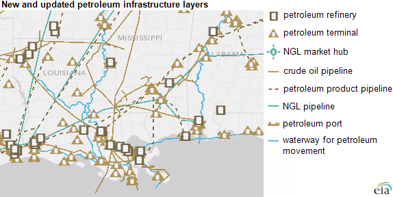
In recent years, midstream U.S. crude oil infrastructure has adapted to increased onshore oil production, leading to some changes in crude oil and petroleum product movement around the country. To help users understand and keep up with changes in petroleum infrastructure, the U.S. Energy Information Administration has added new petroleum layers to the maps on its State Energy Profiles and Energy Disruption pages.
EIA\’s State Energy Profiles and Energy Disruption pages have always included map layers for petroleum refineries, petroleum-fired power plants, and government stockpiles of crude oil (the Strategic Petroleum Reserve) and heating oil (the Northeast Home Heating Oil Reserve). EIA has now expanded these layers to include new asset families such as crude oil and petroleum product pipelines, as wells as petroleum terminals, petroleum ports, waterways for petroleum movements, natural gas liquids (NGL) pipelines, and NGL market hubs. The new layers also provide updated information on crude oil refineries and petroleum power plants:
Categories: Energy, Transportation
